
WE WON!
Ower Beg is overall winner Galway County Council and GRDs Golden Mile of Galway 2014!
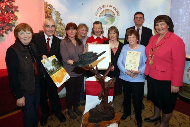
Smiling faces all round as we receive our trophy.
We are delighted to report that we were this year’s winners of the Golden Mile competition, with our OwerBeg entry. We’d like to thank all of the residents, and friends who helped on the project, and especially the staff and children of Kilroe National School for their wonderful artwork.

Some wonderful pictures of our award winning Golden Mile
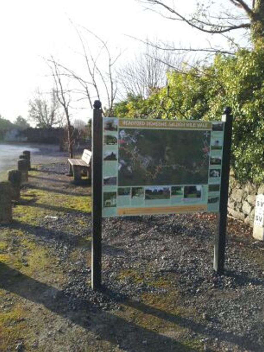
New Biodiversity Sign on Demesne Golden Mile Walk.

A NEW GOLDEN MILE FOR HEADFORD!
The following is a guided tour of our new Golden Mile:
OWER BEG GOLDEN MILE 2014
Our walk starts at the gates of the Burke family’s house at Ower. From Headford take the L3102 Claran road, past the church and school. After 1.8 miles, just past Killursa Graveyard, take the right fork (brown finger signposts to Ballycurrin Lighthouse and Ballycurrin House. Travel .6 of a mile and the Start sign is on your right, outside the gates of Ower House home of the Burke family. The fields to the east of the road used to be part of the home farm. However the Burke family owned most of the surrounding land and leased it to local families who farmed the land. The house, which is now ruined, was once thatched.
To our left there is a gateway with part of an old gate and set into the boundary wall, a carved stone), with the inscription Jos Burke, 1850. In the 19th century, Joseph succeeded his brother, John, and these two men carried out improvements, built walls, a school, striped the lands giving the tenants compact holdings and John was a contributor to the building of Claran church. There was a big lake at the rear of Ower House to Moyne Bridge, which filled from October to May and was used for sailing. There are tall, mature trees at the entrance.
Sir William Burke Teeling wrote in 1932 ” all that remains is a gate near the house leading into the orchard. This, of wrought iron, was originally in the Market Square at Tuam. My great-uncle John Burke purchased it to beautify Ower. When Ower was being sacked, according to Dermot Donelan, they came to take the gate at night, (it being too heavy to remove at the first sacking) and there they all swear they found the ghost of John Burke in a beaver hat and a cut-away coat protecting his gate. So they have left it standing to this day!”
On the other side of the road is a two storey dwelling house which once had the post office for Ower. John Toher remembers his mother working at the post office before it was moved to a house nearby. Behind Toher’s house stands the old shed, and the rusted remains of an old diesel powered saw mill – Toher’s ran a large wheelwright business in the past. A young man, John Heneghan of Knockdoe, served his carpentry apprenticeship here, and wrote The Lovely Sweet Woodlands of Ower.
Turning right into Ower Beg at the side of the house, we pass high dry stone walls on our left hand side, possibly part of the old Burkes demesne. Mr Toher says that stones were collected from the fields and piled on the walls to clear the land. These walls run for some distance. Tree species to spot here are elder, sycamore, ash, three Scots pine Rowan, white beam, juniper, holly and hazel.
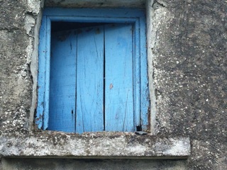
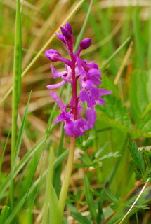
Just beyond this on the right are spread the fields of a local organic farm used for the production of organic sheep and cattle. Amazing views of Partry mountains can be seen to the right. Shrubs alomg the roadside include dog rose, burnet rose and blackthorn – the fields look alive with the breezes moving across the grass. Herbs to look out for are herb Robert, plantain, pineapple weed, clover, daisy, thistle, ferns, dog violet, some vetches, birds foot trefoil and early purple orchid. Bring your wildflower book on your walk! Rounding a bend is another view of the Connemara hills behind Moycullen and Oughterard and the house where Kathleen McDonagh (nee Welsh) was born The old house had a blue painted access door in the gable.
Kathleen married Pat McDonagh and built a house right next door to the family home. Their house is surrounded by conifers, the remains of a Christmas Tree business which they started . On the left hand side, a field of white clover follows the McDonagh house – this clover will be used as a green manure and dug into the soil. This will be followed by other crops such as swede, grains and cabbages.
We then come to a derelict thatched house on the right. It has lovely features such as sash windows and plaster decoration round the gable window There is some interesting farm equipment in the yard and the old fields are still farmed.. There are the remains of weavers cottages behind this house.
Next on our left we come to Nigel and Molly Malcolms house. The thatched house has been in the process of renovation for the past few years. A new thatch and lime render inside shows that it is possible to sensitively renovate old buildings. An extension, cladded in galvanized steel and well insulated, has been added to give the family extra room. Nigel is an amateur photographer and has taken many lovely photos of this and other areas.
Around the bend and you have more spectacular views over the Connemara hills and further to the north the Connemara mountains. On your left is the old family home of the Nally family, which pre-dates the first survey undertaken by Ordnance Survey Ireland in the 1830’s.
On the right hand side, is a wonderful area of limestone paving. Within this small area, of only a few acres, are to be found species from four different limestone habitat types, limestone woodland, limestone grassland, limestone heath and karst limestone pavement. Hazel woodland, wild orchids and ferns abound and it was about this area that the song `’Lovely sweet woodlands of Ower” was written by John Heneghan.
Continuing on our walk, the woodlands continue along the right hand side of the road. These woodlands were once quite extensive.
We are now heading downhill back to the main road. On our left is another old derelict cottage and our walk finishes at the junction with the main road.
Golden Mile 2012: Headford Demesne
The Demesne walk is accessed from the N84 Main Street, Headford, turning right at the old Bank of Ireland and then second right again. The ruined house otherwise known as Headford Castle was the home of the St George family. The ivy clad ruin that stands there today is the kitchen area of the house and and our walk starts at a small gateway into the kitchen garden at the rear of the house. Ann Connolly Architectural Heritage Consultanti concluded in her report on the castle that red brick found in this area would have indicated ovens, possibly a bakehouse and the ‘garden hot room’ would have been heated by pipes from these ovens.
To the right of the Golden Mile Start sign is a wall which was part of stabling for the horses and carriages. Known as the Lime Walk because the lime tree avenue in the Demesne would have started here, (the missing gate pillars were relocated to St Mary’s Catholic church, Headford) the road we follow is now known as Deerpark Woods. On our right are small low lying fields and beyond these fields where the Mart now stands once stood a hazel wood. Just a little further on, on the right hand side is the Headford Wastewater Treatment Plant. Opened earlier this year, the plant is extremely well camouflaged, and does not encroach on the beauty of the mile. The Annacutra Stream and bridge are next, and trout fry can be seen from the bridge. A high wooden fence on the left hand side of the road, backs the Deerpark Woods estate and on the right are hedgerows.
Rounding a bend to the right, the wonderful stone walls of the orchard come into view, with a field of hawthorn on the left hand side. The orchard walls are covered with fairy foxglove in April/May. Apparently this was set into the lime mortar when the orchard was built. A rustic fence runs along the perimeter of the orchard with a 2 metre wild verge inside. On the left hand side is one of several beautifully handsmithed iron gates on the walk, one inscribed Hynes of Ballinasloe, although there is no record of this blacksmith now. There was apparently a sandpit to the left of the orchard, and sand was drawn from this pit to the build the walls. The owner tells us that originally there would have been high wooden gates with an archway. At the back of the orchard you can just see an old well and the entrance to the orchard was lined with beech hedging, which has now grown to fully mature trees. From here in the distance you can see the Connemara Mountains.
Just beyond the orchard, at an old hayshed, we turn left into a right of way, known as Weasel Park. This is the original name taken from the tithe ledger (O’Donovans Field Name Books)ii. The Demesne lands were divided about seventy years ago and the wall on the left hand side of the boreen is original from the time of the St Georges. This is indicated by the wonderful vertical capping stones on the wall. On the right hand side the fields are undulating and looking towards Castle Hackett, Belclare and Cnoc Ma. At the end of the boreen on the left is low lying land which floods during winter and is home to bog iris in the summer.
Turning right here, we pass an early 20 century bungalow on the left and then across in spring we come a wonderful display of lady’s smock or cuckoo flower (cardamine pratensis). This is a very important plant for wildlife, especially the orange tip butterfly (Anthocharis cardamines). Now the area becomes more developed with several new houses as we head to the main road. On the left can be seen over the fields, the old water tower which used to service the town. A description of the demesne says that the Annacutra stream ‘supplied all the apartments of Headford Castle with water’.As we reach the
Golden Mile finish sign, we can see the Grand Gates, which form part of a wall at the main road.
Ait aoibhinn ciuin an mile orga seo. Baineann muinntir na h-aite an- taithneamh sa bheith ag siuil annseo. Ta Radharceanna deasa , agus chomh maith ta na rudai is fearr sa dulra le feiceail agus le cloisteal annseo. Ta ceol na n-ein a luamar sa chunntas Le cloisteal ar maidin agus trathnona. ta Fuaimeanna an nadur le cloisteal ,mar shompla fuaim an abhann ata ag rith sa timpeallacht. Nil aon tracht ar an mbothar agus da bhri sin is ait sabhailte e do og agus aosta
